A Brief History of Adams County, and Our Adams Countians Within It
Part ofthe Pa Chapter  within Volume I: Our American Immigrants of the Within The Vines Historical Family Study 
Relevant  Other  Pages : The Native Americans of South Central Penna and Gettysburg, Adams Co.,  and Our Gettysburgians of the Battle

Within the  Vines Home**Copyright and Terms of Use **Email Webmistress

Table of Contents This Page:
[Inccludes: Intro, Settlement and General History , Blunstone Licenses , Adams Co towns [boroughs] settled or laid out dates , 
 Our Adams Co Families and their tnsps of residency, links to persons within the Genealogical portion of website]
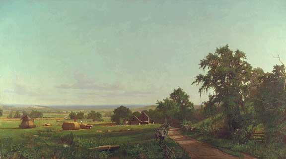
Painting Entitled Adams County, Pennsylvania, 1870 by Hugh Bolton Jones (1848-1927) 
Oil on Canvas. Presented by Spanierman Gallery
Surnames of Adams Co., or of York Co. in that Part Which Became Adams
McCurdy
Troxell
Bender
Swope
Slentz
Meals
Wives Surnames suppressed by marriage to above, who made Adams or York Co [in that Part Which Became Adams] their home
Creighton , Dotterer, Moller/Mohler , Moore/Moor, Schnebele, Schneider
Gyloy [Under Resarch], 
Baughman/Bachman
Spangler, Stair, Bentz
Reinecke, Howard.

Table of Contents This Page:
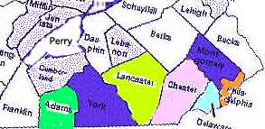
Adams was formed 1800 from York County [See its map
 York was formed 1749 from Lancaster County. 
Lancaster was formed 1729  from Chester County. 
Chester was one of the three original shires, or counties, of Pennsylvania. 
which also included Philadelphia and Bucks
Table of Contents This Page: 

Relevant to our specific ascendancy are families involvedin the earliest history of both northern and southern Adams County with precense in the county far predating the first "town" where are earliest ancestor can be found.  Members of all families can be found in Evergreen Cemetery. The Boroughs and Townships  to which the Boroughs pertain in Adams County follow. 
Introduction
Adams County's early european history involves largely Penna German and Penna Scotch Irish settlement  [and  includes Hollanders involved in the Two Taverns and Hunterstown region, between the regions of Penna German and Scotch Irish settlement ] . In its history is   a Penn family manor [Maske in Cumberland twp] with squatters present upon it [Scotch Irish] unwilling to relinquish it to its proprietors Penn;   Digges Choice, a Maryland grant,  in its southwestern region [predominantly German but also involving Scotch Irish and involving today's Littlestown Adams County and Hanover, York County Pa ] epitomizing the sometimes bloody and always passionate conflict resonant in the disputed border between Pennsylvania and Maryland's proprietaries;  and  Indian incursions involving raids, abductions and killings  in the 1750s involving all the settlers in its terror but leaving the westernmost Scotch Irish particularly vulnerable. This 1750s terror is felt the result of the disenfranchisement of the native Americans occasioned in The Walking Purchase of the late 1730s, which our direct James LOGAN of the Howard Allied Ascendancy was framer of.  Because of the native American removal west and the anger and resentment among their peoples resultant, the Delaware Indians aligned with the French moving down the Ohio Valley...and terrorized the British aligned settlers occupying the lands of their recent forebears in the Pennsylvania arena of the French and Indian War. 
The Conewago settlement in Adams Counties southeast  , relevant to Digges Choice, [TROXELL, HOKE ,   and  EICHELBERGER surname involved-TROXELL being in the region cut out to form Adams, while HOKE and EICHELBERGER are found in the further eastern Digges Choice region which still pertains to York in the area of Hanover ]  received mostly German settlers in the early 1730s . In the north of the county Germans were settling at about the same time [MEALS, GYLOY, SCHNEIDER, BAUGHMAN, SCHNEBELE, BENTZ and  BENDER relevant] . Between them, but laying west and  very close to the Maryland border, the Manor of Maske saw Scotch Irish arriving  at roughly the same time [McCURDY and Allied relevant] .

 
Accompanying Pages 
Within This Site
The Manor of Maske in Adams County & the history of Cumberland Township 
Adams County in which it is found
Digges Choice in Adams & York Counties 
Relationship of the German & Scotch Irish settlers in Adams County
George Washington Describes this region [diary entry]  on his way to York
Some Early Images of Adams County

Related Pages: 

Our Pennsylvanians
Pennsylvania History Title Page
Links Outside These Pages:
 
Wilt's Historical Map of 
Adams Co 1800
AND:
A discussion of its contents
with reference to Manor of Maske
Slave count 1780 Adams Co
[appears in the York index, as Adams then pertained to York]
Adams County towns and 
years of formation
Adams Co township 
Formation Chart 
including years and map
Geographically Detailed Map 1872 showing townships , rivers, towns 
[browseable and VERY useful for identification of towns for first roads discussed in text at right->]
Great , easily negotiated, 
detailed map of all Penna
1895
[USEFUL REGARDING 
THE FIRST ROADS 
discussed 
in text to right->
Historical Images and texts
of Adams County , and Gettysburg
Adams Co Tidbits
Great resource;  history 
of the county in honor
of its Bicentenniel . 
A must visit website.
Adams CoToday 
Concise Stats utilizing
U.S. Fed agency
sources
More Historical Links
Geneological 
Research Links for
Adams Co
Surnames of Adams Co., 
or of York Co. in that Part 
Which Became Adams
McCurdy
Troxell
Bender
Swope
Slentz
Meals
Wives Surnames suppressed by 
marriage to above Surnames and 
who made Adams, or York Co. in 
that Part Which Became Adams, 
their home
Moller
Schnebele
Schneider 
Gyloy [Under Resarch]
Mohler
Baughman/Bachman
Spangler
Stair
Bentz
Reinecke 
Howard
Settlement and General History 
The first sale of lands to individual white settlers in Adams County did not occur by the proprietors Penn but by a Marylander, John Digges who, in 1731, initiated sale of  his chosen grant  from Lord Baltimore  three years before the official  survey defined its region known as Digges Choice. The first Adams Countian  is often  said to be Andrew SCHREIBER who purchased land from John Digges in 1734, but in the region of the future Fairfield there is known to have been an Indian Trader preceeding Shcrieber and present in 1718.Footnote 1  The grant known as Digges Choice established this Maryland property  as lying in the region of the future Hanover, York County, Penna in the east and extending to the area surronding the future Littlestown, Adams County, Pa. in the west and the description of Andrew Schreiber's experiences and circumstances on settling gives insight into the very earliest days of European settlement in this county. 

The Penn family, involved in the acquisition and purchase of land west of the Susquehanna, did not formally encourage settlement on Indian lands,  but grew frustrated knowing that  illegal settlement was sparsely but nevertheless occuring without benefit to them, and starting in 1734 they  finally issued,  before the treaty with the natives ceding lands west of the Susquehanna was signed, Blunston licensesF1  fulfilling their desire to both catalogue and profit  from this expansion.   Two years later  the Penns purchased all the region lying west of the lower Susquehanna from the natives , and the region now known as Adams County pertained to Lancaster Co., being thus enveloped with the 1737 purchase of a sizeable tract of land  involving  "all the land west of the Susquehanna to the setting sun" as described in the purchase agreement. The Penns then began selling lands throughout the newly acquired territory [ including the land involved in Digges Choice thus bringing to odds settlers of that region some of whom were living there under Maryland grants]. Within a short time, mostly Scots-Irish began to settle in  the Bermudian, Conewago and Marsh Creek watersheds." 3 The first mill in Adams County existed  "As early as the 1730s, [when] William Wiermanís  mill on the Bermudian Creek was operating. [As a result of its abundant streams milling would become  the first major industry of Adams County 3

Ongoing westward movement brought  settlers moving into now Adams County,  often settling in ethnic bundles, including the largely Scotch Irish of the considerable territory pertaining  to what became the Manor of Maske, and the Marsh Creek Settlement, and the Germans locating outside of  that  region. As settlement grew, roads were requested;  the Adams County towns mentioned to identify  the area's first roads are our present day markers and regard  "towns" not yet conceived but often identifable  by this  map .   "In February 1747, people petitioned the Lancaster county government for a road to be laid out 'from the Conocheague  through the gap in the mountains of Lancaster.' Known as the Blackís Gap Road, this roadway approximately followed the present trace of old Route 30 from York to a point 2 miles west off to New Oxford [ in now York County] where it bore off to the northwest and passed through the present sites of Hunterstown [ 6 miles east of Gettysburg and in now Adams Co] , Mummasburg [north of Gettysburg by about 6 miles on the road to Arendtsville in now Adams Co] and the Cashtown Pass [ Cashtown is 8 miles west of Gettysburg also in now Adams Co] .... Later that same year, a second major east-west artery was surveyed that linked the headwaters of the Antietam Creek with York and Lancaster. Later known as the York-Nicholsí Gap Road, this highway branched off the Blackís Gap Road about two miles west of New Oxford [ in now Adams County] and approximately followed present Route 30 to the site of Gettysburg [not yet a town, but  in now Adams ] . From there it paralleled Route 116 through Fairfield [in now Adams Co] and the Monterey Pass."3  "As early as 1756, Thomas Butler operated a licensed tavern in Germany Township. By 1800, there were 49 such taverns in the county."3 On August 17, 1749 the provincial Assembly separated York County from Lancaster County and officially partitioned the new county, and so our Adams County pertained to York from 1749 until Jan 22, 1800  at which time  Adams was formed from York and consisted of  of 339, 133 acres covering 531 square miles4.

Adams County has 21 townships [see map]. Littlestown can claim it is the earliest town of Adams County being laid out by Peter Klein [Klein is Little in German] in 1765, during the Mason Dixon Survey and before the Mason Dixon Line was established. First known as Kleina Stedtle, it was then called Petersburg, and finally Littlestown, and it was just two years later that our Troxell line made their residence in its environs. Settlement in  the Littlestown region occured  far before the town was conceived  , its area comprising the western most border of  Digges Choice,  the  history of which involved violence and lawlessness resultant of  the disupute between Maryland and Pennsylvania regarding which colony promoting its settlement actually was the area's owner...a dispute  not fully resolved until the Mason Dixon Line drawn in 1768.  The region of now Hanover , York County Penna, marked the westernmost area of Digge's Choice.   Peter Klein, the founder of Littlestown,   was granted a patent in 1760 for 311 acres which he systematically arranged into the original 48 lots of the town we now know as Littlestown. A similar concept was later  followed by James Gettys in regards to Gettysburg. Nine years later, and one year after the Mason Dixon Line was determined,  a major road was undertaken passing through Littlestown  itself.  "In 1769, a highway was laid out, part of which became known as the Shippensburg-Baltimore Road. Beginning at Sarah Blackís tavern (site of Mummasburg -editors note: ipart of Franklin township , Adams County , about 6 miles from the future Gettysburg and to its northwest reviewed in text and photo in Franklin Township  Webpage),[the highway] tracked to the southeast crossing the York-Nicholasí Gap Road at 'Samuel Gateís' tavern and passing through Peter Lintelís town before crossing the province line. In 1786, James Gettys laid out 210 lots on his 116-acre tract about the intersection of those roads. In part, due to Gettysburgís central location at the intersection of two major roadways, the town was selected as the county seat of Adams in 1800, beating out Hunterstown and New Oxford for that honor. 3 In 1809, the Gettysburg-Petersburg (Littlestown)  pike of ca 1807 "was proposed and granted [to]  continue westward from the Gettysburg square, to connect that town with Cashtown and Chambersburg. Prior to the construction of this turnpike there was no road running westward from Gettysburg. The Hagerstown road jogged off to the southwest after reaching the crest of the ridge west of Gettysburg, and the Mummasburg Road (constructed ca. 1767-1770) ran in a northwesterly direction from the town. An old dirt  road connected these two and ran from the Hagerstown Road at the crest of the ridge in a northwesterly direction, towards the Upper Marsh Creek Presbyterian, or Black's, Graveyard."

George Washington, mentioned his journey through this region on his way to York. See diary entry

Relevant to our specific ascendancy are families involvedin the earliest history of both northern and southern Adams County with precense in the county far predating the first "town" where are earliest ancestor can be found.  Members of all families can be found in Evergreen Cemetery. The Boroughs and Townships  to which the Boroughs pertain in Adams County follow. 


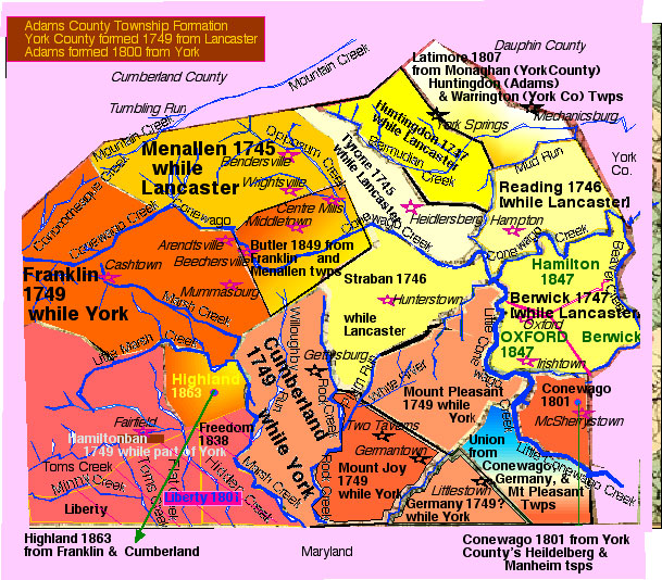
Adams County Township Formation 
Included are Adams County Townships to which they pertain when the area is relevant to our forebears in Adams County
Map copyright C Swope and Within the Vines


More Towns than here evident  are found in the List  of Adams County 1900 from Genweb

Towns of Adams County, Settlement and Formation History
[ Below this list are the townships of relevance to our forebears of Adams County , who they were, and links to their own pages] 
  • Abbottstown settled or laid out 17551 [Brief settlement and town history of Abbotstown ]

  • Abbotstown is found straddling Berwick and Hamilton Townships.map [ Berwick was  formed 1747 while part of  Lancaster Co.,  Hamilton formed 18102]
  • Arendstville, 18101 [Brief settlement & town History of Arendstville ] in Franklin townshipmap [ formed 1785 while part of  York Co2]
  • Bendersville 18111 [Brief settlement and town history of Bendersville]  in Menallen Townshipmap [formed 1745 as part of Lancaster County, and subdivided with Franklin to form   Butler 18402] Bendersville was Founded by the brothers of our direct Bender Ancestor Elizabeth Bender in 1732.
  • Biglerville 18171 [Brief settlement and town History of  Biglerville] in Butler Townshipmap  [formed 1849 from Franklin & Manallen Twps2]
  • Bonneauville 17551 [Brief settlement and town History of Bonneaville]   first known as "Bonnaughtown"] This is probably[??] the Bowmansville in Mount Pleasant Townshipmap .
  • East Berlin  17461 [Brief settlement and town History of East Berlin]
  • Fairfield 18011 [Brief settlement and town History of Fairfield] 1st settler west of Susquehanna lived at the site of this future town.
    • John Hanson Steelman, believed to be the first permanent European settler west of the Susquehanna was  born 1655 in Philadelphia. "Hance" Steelman became an Indian trader and interpreter east of the Susquehanna and in Maryland. He operated a trading post after about 1718 along an Indian trail near future Fairfield in western York County, now Adams County and died  in 1749 7
  • Gettysburg 17801 [incorporated 1806] [Brief settlement and town History of Gettysburg] This borough is surronded by Cumberland Townshipmap [Cumberland was formed 1749 while part of  York Co and Highland was formed from Cumberland in 18632
  • Hunterstown: {The Lower Dutch Settlemen"Location: From 2 miles east of Hunterstown--along the "Low Dutch Road" - S of W to the Baltimore Pike, thence south to Two Taverns (between the German and Scotch-Irish sections of Adams County, Pa.   Date of Formation: Earliest emigrants were in 1765 and the main migration was in 1771. " from Summary - The Low Dutch Colony of The Conewago   - Rev. J.J. Demarest 1884found in the Conewago Colony page of The Cayuga County  NYGenWeb Project . Same page goees on to say "extended from a point two miles east of what is now Hunterstown....along a road running in a south-westerly direction to a point a mile or less across what is now the Baltimore Pike, and down the pike to the Two Taverns. This road is still known as the Low Dutch Road, and is so called on the maps and in the text of the third volume of the Count de Parisí History of the Civil War." In this case, the Dutchmen are Hollanders involved with the settlement.
    Regarding the 1800 townships and what we can learn from them as presented by PHMC at their discussion of the Wilt Historical map of Adams County found in the Penna Archives pages:
       "Adams, consisting of 339,133 acres covering 531  square miles was formed from York County in 1800, and reflected the area's  inhabitants desire for courts closer to their residences. Named for the nation's second president, John Adams, it exemplifies the respect  that some early Americans had for the new nation's leaders. Within counties are cities, of which Adams County has none; townships, twenty-one of them in Adams County, two of which were named for other early national leaders: Benjamin Franklin and Alexander  Hamilton; and boroughs the largest of which is the county seat of Gettysburg, designated as such in 1806. Pennsylvania's cities, townships, and boroughs are governed by elected officials." This page also disusses the precense of the different ethnic groups in the county, stating "The townships of Reading and Oxford indicate English influence; Tyrone and Latimore, Irish or Scots-Irish; and Germany may reflect the presence of settlers from these countries. Among the early residents were immigrants from German-speaking lands: Peter Arendt, Andrew Schreiber, Nicholas Weirman, and others. Of Scottish and Irish origins were William Gilland, David McNaughy, and Robert McPherson. Duncan Evans was of Welsh background. Walter Buchanan and David Wilson had a Scottish heritage. The map implies at least the temporary residence of African Americans also. Adams Countians worshipped at the Roman Catholic Conewago Chapel and certainly in Presbyterian, Lutheran, and Reformed churches, though none are shown on the map. They studied first at the school operated by the "Kreutz Kirche" (Church), probably German Lutheran and Reformed and at the Lutheran-run Gettysburg College and Theological Seminary."4from [discussion of the information of Wilts Historical Map Adams County    found at PHMC pages of the Penna Archives webpages


    Adams County is a largely rural region and its largest town is Gettysburg , designated the County seat  in 1806, followed in populace by Littlestown at its southern aspect on the Maryland border.  Gettysburg is a town of about 8000 while Littlestown has roughly 3,500 people. As late as the early 1980s it was not unusual to see Amish buggies moving between these two towns, their being some Amish remaining in the southern aspect of the county whose business sometimes took them to the county seat. Today, however, the Amish appear to have moved on to other  communities  and this image is not seen in the county any longer.

    On to Our Northern and Southern Adams County Lines with links to the Surnames present in Adams County
    Top of page


Our Northern and Southern Adams County Lines by Geographic Local:
[See Link to the Surnames present in Adams County by date of first known ancestor]

In Aggregate our Surnames involve North Adams [Bendersville, Menalen and Butler Townships] Southern Adams [Gettysburg Borough, Cumberland Township [and the Manor of Maske within it] , and possibly Eastern and Southeastern Adams [Mt Joy Township and Hunterstown, Straban Township], felt to be the in the as yet unproven ascendancy of the Slentz line found in Gettysburg. 

Northern Adams and our Surnames: 
Bendersville ,  Menallen and Butler Townships
Bendersville 18111 [Brief settlement and town history of Bendersville]  in Menallen Townshipmap [formed 1745 as part of Lancaster County, and subdivided with Franklin to form  Butler 18402]
This region involves our Bender, Gyloy [married Bender likely in Germay] , Schneider, Baughman, Schnebele ,  and Meals Surnames.

Bendersville was Founded by the brothers of our direct Bender Ancestor Elizabeth Bender in 1732. 

           
    Southern Adams and our Surnames:
    Gettysburg, Cumberland Tsp  and the Manor of Maske within it,  and Littlestown ,  Germany Township
     
      Cumberland Township 
      Cumberland was formed 1749 while part of  York Co and Highland was formed from Cumberland in 18632
      Gettysburg is surrounded by Cumberland Township.
        Our Slentz line was present living in Cumberland for the 1850 census, but resided in the town proper of Gettysburg before and after. 
        Our later Swope line [1910 and beyond] are also found in Cumberland township as their home in now northern Gettysburg was in the country surronding the borough until that area saw more development and so became part of the borough of Gettysburg itself.
      The Manor of Maske within Cumberland Township 
        Our McCurdy and allied lines lived on the land that became part of Cumberland township forged from the Manor of Maske. Creighton was the wife of our McCurdy who settled Adams. 


      Gettysburg Borough 

      Gettysburg is surrounded by Cumberland Township.map
      Gettysburg was founded 17801 [incorporated 1806] [See Brief settlement and town History of Gettysburg
      Gettysburg Borough  involves our
      • Troxell and Mohler lines [ In 1787, the founder of Gettysburg, James Gettys, sold his first plot of land to John Troxell, Sr. He opened the first tavern in Gettysburg; now the James Gettys Hotel. He married Elizabeth MOHLER, but her birthplace is not yet known. Also in the borough was our
      • Swope line present and engaged in business in the nascent town itself  1806 through to the current generation. By the second generation the family was  present working and residing on the North west corner of South Streets and Baltimore [ across the street from  the now Farnsworth house] , in a region of manufacture suitable to the family business [tannery for dad and saddle tree making for his son] . By 1850  the Swope directs escaped the fumes of that area of town and established residence with extended family on York Street , while the next generation lived on Baltimore almost at High Street, and finally , the last two generations are found on Broadway, in the first home not a farmhouse built on that street in Gettysburg and then pertaining to Cumberland Township.  The Swope line from the first generation was involved in municipal affairs, the settler of Gettysburg being on the town council, and later generations serving in like capacity, with the third serving as judge, and fourth, fifth and sixth as attorneys.
      • Slentz line in the form of  John born in Adams County 1792 in township not yet secure, however he is found in the borough of Gettysburg for the 1820 census, involved in comerce [residing next to John Troxell above mentioned] . John Slentz served on the Gettysburg Town Council in 1830 and 1831. He  married John Troxell's daughter in 1815.
      • Meals ancestors of  later generations, they having moved down from north Adams [Menallen Township formed later into Butler twp] and found engaged in stone work in the town of Gettysburg and present there in census of 1850. John and Anna Maria [nee Troxell] SLENTZ's daughter Henrietta married Gabriel MEALS, a stoneworker like his father.  They resided on Buford Avenue in the later portion of their marriage, first residing in Emmitsburg, Md. where he pursued his profession.


      Littlestown and  Germany Township 

        Littlestown 17651 [See Brief settlement and town History of Littlestown] [Union and Germany Townships]
      • Littlestown was the home of our Troxell forebears [in the form of Daniel TRACHSEL]  BEFORE a son  emmigrated to Gettysburg .  A warrant of Land in York [now Adams County]  was issued him 1775. In 1779 he  resided Germany township. Daniel Troxell was buried in Littlestown in  1814.
    Eastern and Southeastern Adams
      It is felt but not proven that the John Slentz  marrying in Gettysburg 1815  to  Anna Maria Troxell has ascendancy within the Slentz line found in Mount Joy township, and in subsequent generation in Hunterstown and Straban Township. 
    Top of page

Adams County Surnames 
[Adams was part of York, previously part of Lancaster , and  was formed 1800]: 


BENDER, Jacob  [son of Jacob BENDER whose will was probated in Philadelphia County]
 Jacob emmigrated to Menallen Township of then York [now Adams County] where he died in 1786. His four sons were the founders of Bendersville, Adams County, Penna.

Schneider, Catharine , wife of Jacob Bender,  was born in York County [unknown if part relative to now Adams County as her ascendancy is not determined] and died in Menallen Twp, now Adams County in 1786.

TROXELL, Daniel
Bought land in Bucks County in 1752, rec'd land from his father in 1758 which he farmed until Dec. 26, 1767 when he sold his land in Lehigh County, Penna and moved to York [now Adams [ County] to the Littlestown region. A warrant for 50 acres was issued On 25 April 1775 , and he is found on the  1779 tax list for Germany Township, and in 1790 for the census of York County in that region. His wife Sophia DOTTERER was born in Philadelphia County and her first child was born in Bucks County.

  • Daniel Troxell's father  Peter TRACHSELL , his wife Juliana Catharina TRAUTHAGER, , and two eldest sons [Daniel included] Arrived Phily 1733 and Peter and Juliana Catharina first settled in  Egypt, Pa, then in Bucks County, and then moved 5 miles away to the lower Jordan Valley where they were first settlers of this region of now Lehigh County,  and after 12 Jan 1754Settled Frederick County, Md. which borders Adams County on its southern aspect in the region near Littlestown. At the time of his movement to Frederick County, the mason dixon line [determined 1768] was not yet established and the border between Penna and Maryland, particularly in this region, was in dispute. Within one year, their son Daniel and his family would move to join them nearby, in the  Littlestown area. Our next generation TROXELL,  Peter TROXELL [son of Daniel of Littlestown] married Elizabeth MOHLER, and Peter is credited with building  the first home in Gettysburg,  on site of present courthouse.

  •  

    MOHLER, Elizabeth was born ca 1759 [64 at death 1 Sept 1823 according to newspaper clipping ] and she married her husband at present in unknown locale. Her ascendancy is under research. She was married to Peter TROXELL and it is unknown where she was born

    Meals, Johann Samuel.
    Born in 1711 in Baden , Germany, he arrived in America Sept.26,1741 on the ship St. Mark into Phily.He died Menallen Twp, York (Now Adams Co.) Pa 15 Nov 1795. Johann S Mihl is found on the DAR Plaque of Benders Church, Bendersville, Adams Co., Pa. His apparant children were born in 1737, but his exact date for residence in Menallen Township is unknown to me.  His wife, purported to be
    Maria Charlottha GYLOY, is said to be buried Bendersville with him, but I could not find her gravestone there. Her ascendancy is under research.

    Kindigen [Kindig]  Kindigen is very likely the female form of the name KINDIG, but her father is often presented as Martin KINDIGEN.
     Maria Stinia [Mary (Catharine)] Kindigen; on her tombstone it says MARIA STINIA SPENGLER, is said to have married her husband Jonas Spangler in 1743/4 in that portion of York County now pertaining to Adams. She and her husband are both buried  in York County's Pigeon Hill Cemetery,Paradise Hill,PA [Paradise(Now-1896-Jackson Twp) PA] . Her father was Martin KINDIGEN or KINDIG. He is under research

    BAUGHMAN, Christian  Arrived  1791  and
    He was born 1755 Baden Baden, died 1802 in Adams county, Penna.

    SCHNEBELE, Elizabeth [wife to Christian Baughman]
    born about 1762 Germany, she died 1861 at 99 years in Adams County, Penna and is buried in Evergreen Cemetery.

    SLENTZ, John
    Born 1792 in York, now Adams CountyPenna.Hisascendancy is elusive to the extreme but likely involves the Slentz's present in Mount Joy Township of now Adams County Penna who themselves descended from the Slentz's of York County. He married Anna Maria Troxell, daughter of Peter above mentioned. The Slentz line moved down from Menallen Township [formed later into Butler twp] and found engaged in stone work in the town of Gettysburg and present there in census of 1850

    McCurdy, Robert, son of James and Polly [Cooke] McCurdy of Salisbury Twp, Lancaster Co, Penna, he emmigrated to now Adams County Penna [then part of York County] by 1780. His land pertained Cumerland township and a region  known as the Manor of Maske, on the Marsh Creek, in lower Adams and near the Md Border and it was passed to his sons. 

    Creighton, Anne, wife to Robert McCurdy above mentioned, she  moved with him from Leacock Twp Lancaster to  York, now Adams County and apparantly died [ in the region of Manor of Maske] before 1805, where and when  her husband's will was written. As her family is known but not excessively detailed, it can not be excluded that kinship on her part may have led to Robert and Anne's removal to Adams. 

    MOOR/MOORE , Martha , born Md 1787 [ATTENTION, her census indicates a Md birth, but this land falls close to the Mason Dixon Survey, and I have not excluded the possibility her family is closely associated with the Manor of Maske of southern Adams, and Piney Creek Presbyterian in Md which our McCurdy forebears were involved with although they themselves were living in Penna.

    [this grandmother to Judge Samuel McCurdy Swope, was born circa 1787 in Maryland according to Census. Her family is under research. I suspect her to be part of the Scotch Irish Settlement in the southern portion of Adams, in lands disputed by the mason dixon survey, and closely associated with the Manor of Maske . She was married at Piney Creek, near Emmitsburg, Md. to James McCurdy, grandson of the James McCurdy immigrant. He inherited  his portion of the McCurdyfarm that is out Route 15 near marsh creek and in southern Adams County, Penna. The church was further south and over the Penna/Md border.

     Swope, Adam emmigrated to Gettysburg , now Adams County, Penna by 1806 . He was born in Hanover., son of Johann Conrad Swope

    Related Pages:
    To Surnames relevant to Bucks County, Penna
    To Surnames Philadelphia and its environs
    To Surnames  Lancaster County, Penna
    To Surnames  York County, Penna
    To Top of Page
    All Pages of Within the Vines are Copyright©protected. See Terms of Use

    Top of page


    Footnote 1
    Blunstone licenses were warrants for what was not yet legal land, it being in territory not yet ceded by treaty with the natives. A ferry across the Susquehanna existed by 1712, operated by John Harris at the future site of Harrisburg, where he had established a thriving trading post. This ferry served Indian traders from both sides of the Susquehanna, and occasionally French traders travelling the river's banks, and illegal settlers were already present west of the Susquehanna long before the Blunstone licenses began to be issued in 1734. The Penns, recognizing there was no profit in this illegal settlement,  issued about 280 licenses for about 74,000 acres in the future York County, much of which would become the future counties of Cumberland  and Franklin, and a small portion of which  pertained to the future Adams County. The Penns "authorized Samuel Blunston, a Lancaster County surveyor and public official, to issue what were call licenses to persons wishing to take up land west of the Susquehanna River. Most of the Blunston licenses were granted to Scotch-Irish immigrants for tracts in the Cumberland Valley, in what are now called Cumberland and Franklin Counties, along the Conodoquinet, Yellow Breeches, and Conococheague Creeks. A much smaller number were for land in what is now York County along the Codorus and Conewago Creeks. [See Image for position of the larger among these creeks in the lower Susquehanna basin]
    About twenty licenses were issued, most of them in early 1735, for about 8000 acres of land along the upper reaches of the Conewago Creek, and itís tributaries, in the northern part of what is now Adams County. Two were issued, both on April 8, 1735, for a total of 600 acres of land among the branches of Marsh Creek."5

    Blunston Licenses Description by the Penna Archives:
    The State Archives has catalogued the Blunston Licenses and provides detail on the holdings in its possesion. This is placed here for ease of access, as this entry is deep within its pages.
    "Pennsylvania Historical and Museum Commission Bureau of Archives and History Pennsylvania State Archives
    RG-17  RECORDS OF THE LAND OFFICE Series Descriptions
    Blunston Licenses, A Record of Licenses Granted to Sundry Persons to Settle & Take Up Land on the West Side of Susquehanna
    River, [ca. 1736]. (1 folder)  LO 23.1 PLR 71  {series #17.319} [Holdings]
    Arranged chronologically by date of license. Indexed internally, alphabetically by surname of licensee.

    A loose register of licenses granted in lieu of warrants to settlers in Springettsbury Manor in present day York County and along the Conodoguinet Creek in present day Cumberland County and a list of licenses to settle granted to other "adventurers." This series is filed in folder 12 within the series Proprietary papers, [ca. 1682-1788] {17.297}. The practice of granting licenses to settle on land not yet purchased from the Indians created a new category of land. The licenses not only kept track of settlers who went beyond the treaty line, but also carried the promise that warrants would be granted as soon as the land was purchased from the Indians. As early as 1718, James Logan had informally granted permission to a group of Scots-Irish immigrants to settle in West Conestoga Township in what was then Chester County and Deputy Governor William Keith had also secretly given permission for a group of Germans from Schoharie, New York to settle in the Tulpehocken Valley of the present day Berks County in 1723. Despite such early informal arrangements, the Blunston Licenses were the first official licenses authorized by Thomas Penn in 1736 for land that lay west of the Susquehanna River. To protect proprietary interests in the border dispute with Maryland, he granted Samuel Blunston a commission to issue "licenses to settle" to German squatters and other "adventurers" in this region and these resemble warrants and contain much of the same type of information.
    Licenses or certificates were also granted to traders who assisted in military occupation of the frontier and in securing the western fur trade. Examples of these can be found in the gentlemen's tract applications in the East Side Applications Register, 1765-1769 {series #17.37}. Information given is the date of the license, the name of the settler, the acreage licensed, and the location of the tract.

    In all cases where settlement occurred by license, regular warrants could not be granted until the land had been purchased from the Indians. To locate a warrant issued on the basis of a license or certificate, consult the warrant register of the county with jurisdiction at the time. For example, most of the earliest warrants issued on the Blunston licenses will be found in the Lancaster County warrant register because Lancaster County had jurisdiction west of the Susquehanna River until York County was erected in 1749 and Cumberland County
    in 1750. "
    See   the region of Adams County  pertaining to Blunstone Licenses


    Additional Adams County Links:

    More Historical Links than those already given in page areas above:
    Adams County GenWeb [Rootweb]  page, many links to geneological sources, and historical information. A Must Have Resource for Adams County history.
    ROOTS-L Pennsylvania: History many many  links. GREAT RESOURCE FOR ALL PENNA, includes histories on Lancaster, York....Bird in hand is described here, as are most regions relevant to all are forebears areas of Penna.
    Adams County, Penna  From US Cities Online Offering Links to all of The Cities and communities of Adams County, Pennsylvania which themselves provide useful information on those cities and comunities, sometimes yielding specific history links
    Littlestown, Penna History, Littlestown, Penna General Information Links  and Borough Map
    See ACHS own publications page and thenbsp ACHS Information Website
    ADAMS COUNTY HISTORICAL SOCIETY (of PA) PUBLICATIONS PAGE
    Franklin Twp History pages
    Adams County Page from Time Voyagers Pennsylvania Counties
    News, Events, History, & Culture of Northern Frederick County Md./Southern Adams County Pa. from Emmitsburg.net
    See Slavery In Pennsylvania, Adams County Pages  [part of the Slavery in Pennsylvania  webpage]
    Map Links and fundamental history links repeated from top or contents of page:
    Wilt's map accomplished in 1940s, and of Adams County in year of formation 1800, very detailed [from Penna State Archives]
    see also comments on  the information revealed in Wilt's map by the Penna State Archives
    Adams COunty Borough and Township formation by year
    Adams County Bicentenniel  Tidbits [VGreat resource;  history of the county given in seperate pages and researched by the Adams County Bicentennial Committee.

    Geneological [and some Historical] Links:
    Adams County Gen Web Archives
    Rootswebs Adams County page, showing also Web Sites at RootsWeb - Adams PA specific
    LOOK-UPS ADAMS County, PA from Rootsweb offering some online documentation and volunteers willing to look up information in specific publications as provided neatly indexed.
    The South Central Pennsylvania Genealogical Society, Inc. Publications page [York and Adams Relevant]
    Adams County Gen Web Project [Rootsweb's main page  for this county...great links and indespensable resource]
    Lineages Geneology Site [offers hardbound books for sale and so offers insight into research tools]
    Pennsylvania Data Base offerings from Ancestry.com
    Adams County, Pennsylvania, 1785-1874: Lutheran and Reformed Congregations from Ancestry.com


    Sources For this Page  [Adams County Penna and our Adams Countians] :
    1 Adams COunty Borough and Township formation by year   from the Penna Historical and Museum Commision website, thesources for which are given as  Frederic A Godcharles, Pennsylvania Political, Governmental, Military and Civil: Political Civil History Volume (New York: American Historical Society, Inc., 1933) and History of Cumberland and Adams Counties, Pennsylvania, (Chicago, Ill: Warner, Beers and Company, 1886) ]

    2. See Township formation with chart and map from Rootweb.

    3. Adams County Bicentenniel Tidbits. mounted by the Adams County Bicentenniel Committee and presenting an indispensable website regarding the early history of the county.

    4. Pennsylvania State Archives Documents Pages. Wilt Historical Map of Adams County and Text detailing history involved in that map. From County History. Manuscript Group 11: Map Collection, Leo Wilt Historical Maps, 1941-1946, Adams County, 1942

    5. the Manor of Maske: Its History and Individual Properties, a small part of the text available  through the Adams County Historical Society

    6. Chapter I: Early History of the [McPherson] Farm, 1790s-1846 from the webpages of the Gettysburg Discussion Group

    6. Littlestown History Page from Littlestown.net

    7. York Daily Record. History of York County pre 1700


    All Pages of Within the Vines are Copyright©Protected. See Terms of Use
    To Within The Vines Homepage

    Email Webmistress